Vietnam day trips - The life of King of the H'mong, Vuong Chinh Duc, who ruled the Dong Van Stone Plateau for so long, remains shrouded in mystery and legend.
The King of the H'mong, also known as the H'mong King, was a spiritual leader or "lord" of the H'mong community in certain regions of Vietnam, China, and Laos before the August Revolution.
Before the August Revolution in 1945, Vuong Chinh Duc was the king of the H'mong people, with a powerful dynasty that controlled the entire northernmost region of present-day Vietnam, with a population of up to 70,000. Vuong Chi Sinh, his second son and successor before 1945, faced much pressure from various factions. However, Vuong Chi Sinh did not side with the French or Chiang Kai-shek, but wanted to build Dong Van into an autonomous kingdom of the H'mong people.
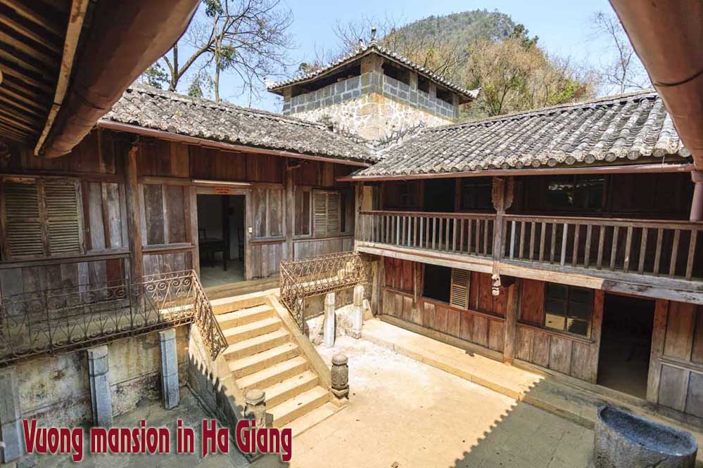
The house of the "King of the H'mong", also known as the Vuong family mansion, covers nearly 3,000 square meters and is situated on a hill shaped like a turtle, surrounded by mountains and forests in the Sa Phin valley, Dong Van district, Ha Giang province. The road leading to the mansion is lined with lush green cypress trees, imported from China. The mansion was built from 1919 and completed in 1928, costing 150,000 Indochinese silver coins at the time, equivalent to 150 billion VND today.
To build the mansion in Sa Phin, in 1890 Vuong Chinh Duc invited a Han Chinese geomancer named Truong Chieu to find a suitable location. After searching throughout Dong Van, Truong Chieu finally chose Sa Phin as the site. The geomancer explained that in the middle of the Sa Phin valley, a hill shaped like a turtle rose up, surrounded by high mountains. Building a house on the turtle's back would bring wealth and prosperity for life.
Behind the turtle-shaped landmass is a mountain range shaped like an armchair, offering space to stretch one's legs. To the right and left are high mountains. In front are two mountains symbolizing literature and martial arts, standing in attendance. Behind these two mountains is a mountain range that stretches across like a winding dragon. Truong Chieu concluded, "This is the land where heroes reside".
The mansion's architecture was influenced by three main cultures: H'mong, Chinese, and French. The mansion has four horizontal buildings, six vertical buildings, and three sections (front, middle, and back) with a total of 64 rooms accommodating 100 people. The walls are constructed of blue stone, the roofs are made of pine wood, and covered with terracotta tiles.
From the very beginning of its construction, Vuong Chinh Duc calculated that this would serve as both a residence and a fortress capable of effective defense, combat, and withstanding the harsh natural conditions of this high mountainous region. Inside, there were also food and weapons storage facilities prepared for any worst-case scenario should a battle occur.
In 1945, President Ho Chi Minh sent Hoang Viet Hung from Cao Bang to Sa Phin to persuade Vuong Chinh Duc to join the revolution to fight the French, Japanese, and Chiang Kai-shek's forces. President Ho Chi Minh then sent a letter inviting Duc to Hanoi. However, due to his advanced age, Duc sent his son, Vuong Chi Sinh, to meet him instead.
Upon arriving in Hanoi, Mr. Vuong Chi Sinh became sworn brothers with President Ho Chi Minh, and was given the name Vuong Chi Thanh. At the ceremony, Vuong Chi Sinh pledged his determination to follow President Ho Chi Minh in protecting the land of Dong Van and leading the H'mong people to join the Viet Minh. He promised to return Dong Van to President Ho Chi Minh after defeating the French and expelling the Japanese. Mr. Sinh later served as a delegate in the first National Assembly and as Chairman of Dong Van District.
When President Ho Chi Minh issued the call for nationwide resistance in 1946, and the national treasury was depleted, Vuong Chi Sinh donated 2.2 million silver coins and 7 kg of gold to the government.
That same year, to affirm his affection and trust, President Ho Chi Minh sent Mr. Bui Cong Truong with two mementos - a military uniform and a sword - to present to Mr. Vuong Chi Sinh. The sword, forged by the Viet Bac military workshop, bore the inscription "Utmost loyalty to the nation". "Not to be enslaved".